Difference between revisions of "Welcome to Urban Securipedia"
| Line 29: | Line 29: | ||
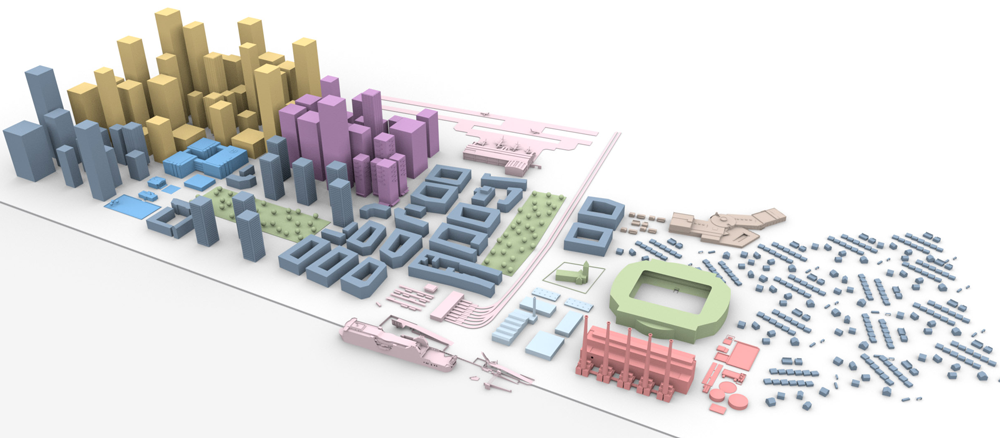
poly 251 152 205 131 159 158 135 121 73 120 68 89 115 60 114 39 164 7 261 17 311 40 319 93 305 89 278 107 278 134 [[Office Employment|Offices]] |
poly 251 152 205 131 159 158 135 121 73 120 68 89 115 60 114 39 164 7 261 17 311 40 319 93 305 89 278 107 278 134 [[Office Employment|Offices]] |
||
poly 141 225 99 205 207 135 251 157 [[Social Infrastructure|Social infrastructure]] |
poly 141 225 99 205 207 135 251 157 [[Social Infrastructure|Social infrastructure]] |
||
| − | poly 215 182 330 220 304 242 186 199 [[ |
+ | poly 215 182 330 220 304 242 186 199 [[Social facilities, open and civic space|Amenity/open/civic space]] |
poly 140 229 366 303 402 273 488 302 510 274 475 260 529 182 437 161 395 207 369 200 263 150 220 180 331 221 304 243 182 200 [[Residential|Residential]] |
poly 140 229 366 303 402 273 488 302 510 274 475 260 529 182 437 161 395 207 369 200 263 150 220 180 331 221 304 243 182 200 [[Residential|Residential]] |
||
poly 319 345 514 411 548 374 358 306 [[Transportation|Transportation (Port)]] |
poly 319 345 514 411 548 374 358 306 [[Transportation|Transportation (Port)]] |
||
Revision as of 18:20, 13 December 2012
Urban Securipedia is an urban security (and connected safety) knowledge base which forms part of a complimentary tool with the objective of assisting and supporting the urban planner to make more informed deliberations and decisions on the proper planning and sustainable development of the urban area, from a security (and connected safety) perspective. Urban Securipedia assists the urban planner in making more informed decisions in the first of three distinguished levels of urban planning. It is part of a complete tool set to support each of these levels, including concept level tools, plan level tools and detail level tools.
To this end, the Securipedia contains a wealth of information on security, brought into relation with the typical areas of interest of the urban planning process.
Urban Securipedia has been developed with the end-user in mind and, accordingly, provides not only free browsing, but also a number of convenient entry points:
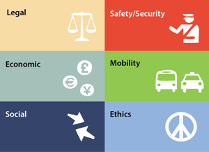
| 1. Enter by context (select from below) |
2. Enter by urban object type (hover over different land uses below) |
3. Enter by specific keyword (as per top right of screen) |
|---|---|---|
 |
 |
Search by specific keyword: <searchbox Size="35" /> |
Urban Securipedia is one of two inter‐related components of computer assisted support for urban planners, to support decision-making with regard to the security of cities concerning concrete problems or goals. Each component, namely the Knowledge Base (i.e. this Urban Securipedia) and the Risk Assessment (SecuRbAn), work closely together in supporting the urban planner in a way that is described in the how to use guide.
Urban Securipedia is developed as part of the Vitruv project, co-funded by the European Commission within the Seventh Research Framework Programme (2007-2013).