Difference between revisions of "Welcome to Urban Securipedia"
| Line 11: | Line 11: | ||
|- |
|- |
||
! style="background: lightgray; border: 6px solid lightgray;" | <imagemap> |
! style="background: lightgray; border: 6px solid lightgray;" | <imagemap> |
||
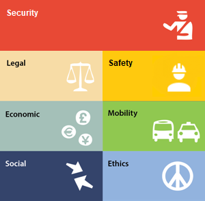
| − | Image:funcissues.png|300px| |
+ | Image:funcissues-2.png|300px| |
| − | poly 2 4 |
+ | poly 2 4 296 4 297 71 5 71 4 5 [[Security|Security]] |
| − | poly 2 76 |
+ | poly 2 76 147 76 148 143 5 143 4 76 [[Legal|Legal]] |
| − | poly 3 149 147 149 148 216 5 216 4 150 [[ |
+ | poly 3 149 147 149 148 216 5 216 4 150 [[Economic|Economic]] |
| − | poly |
+ | poly 3 222 147 222 148 289 5 289 4 223 [[Social aspects|Social]] |
| − | poly 152 76 296 76 297 143 154 143 153 77 [[ |
+ | poly 152 76 296 76 297 143 154 143 153 77 [[Safety|Safety]] |
| − | poly 152 149 296 149 297 216 154 216 153 150 [[ |
+ | poly 152 149 296 149 297 216 154 216 153 150 [[Mobility|Mobility]] |
| + | poly 152 222 296 222 297 289 154 289 153 223 [[Ethics|Ethics]] |
||
desc none |
desc none |
||
Revision as of 08:26, 20 October 2020
Urban Securipedia is an urban security (and connected safety) knowledge base which forms part of a complimentary tool with the objective of assisting and supporting the urban planner to make more informed deliberations and decisions on the proper planning and sustainable development of the urban area, from a security (and connected safety) perspective. Urban Securipedia assists the urban planner in making more informed decisions in the first (concept level) of three distinguished levels of urban planning. It is part of a complete set of practical tools to support each of these levels, including concept level tools, plan level tools and detail level tools.
Urban Securipedia has been developed with the end-user in mind and, accordingly, provides not only free browsing, but also a number of convenient entry points:
| 1. Enter by aspect (select from below) |
2. Enter by urban object type (hover over different land uses below) |
3. Enter by specific keyword (as per top right of screen) |
|---|---|---|
 |
 |
Search by specific keyword: |
Urban Securipedia is one of two inter-related components of computer assisted support for urban planners, to support decision-making with regard to the security of cities concerning concrete problems or goals. Each component, namely the Knowledge Base (i.e. this Urban Securipedia) and the Risk Assessment tool (SecuRbAn), work closely together, thus supporting the urban planner in ways that are described in the when to use page. The how to use page provides a concise step-by-step guide to the use of the tools. Further assistance with the use of the tools can be found in the accompanying manual.
In order to provide practical and useful support, the Securipedia contains a wealth of information on security, brought into relation with the typical areas of interest of the urban planning process, as illustrated below. Click the image for a helpful page explaining the structure and contents of the Securipedia.

This website uses cookies for analytic purposes. By using this website, you agree to the use of these cookies, see privacy policy.