Difference between revisions of "Welcome to Urban Securipedia"
| (126 intermediate revisions by 6 users not shown) | |||
| Line 1: | Line 1: | ||
| − | Urban Securipedia is an urban [[ |
+ | Urban Securipedia is an urban [[safety]] and [[security]] knowledge base for local government and other organisations responsible for or involved in the safety and security of people and objects in the urban area. Examples of Securipedia users are: [[Urban planner|urban planners]], municipality staff and law enforcement agencies responsible for the security of public space, and public event planners. |
| + | Urban Securipedia provides a structured approach to managing risk, providing practical tools for security concept development, security risk assessment and security technology evaluation, among others. |
||
| − | Urban Securipedia has been developed with the end-user in mind and, accordingly, provides not only free browsing, but also a number of convenient entry points: |
||
| + | The knowledge within Urban Securipedia can be accessed either by selecting the aspect of interest, the urban area of interest or simply by searching for a keyword:<center> |
||
| − | {| class="wikitable" cellpadding="0" cellspacing="0" style="background:darkgray; border: 6px solid lightgray;" |
||
| + | {| style="border-collapse: collapse; border-spacing: 0; border-width: 0px; border-style: solid; border-color: lightgray; padding: 0; width:900px" |
||
|- |
|- |
||
| − | ! style="background: darkgray; border: 6px solid lightgray;" width="300" | |
+ | ! style="background: darkgray; border: 6px solid lightgray;" width="300" |Enter by aspect<br><small>(select from below)</small> |
| − | ! style="background:darkgray; border: 6px solid lightgray;" |
+ | ! style="background:darkgray; border: 6px solid lightgray;" width="500" |Enter by [[urban object|urban object]] type<br><small>(hover over different land uses below)</small> |
| − | ! style="background:darkgray; border: 6px solid lightgray;" width="100"| |
+ | ! style="background:darkgray; border: 6px solid lightgray;" width="100" |Enter by specific keyword<br><small>(as per top right of screen)</small> |
|- |
|- |
||
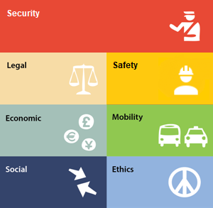
| − | ! style="background: |
+ | ! style="background: lightgray; border: 6px solid lightgray;" |<imagemap> |
| + | Image:funcissues-2.png|300px| |
||
| − | {| cellpadding="0" cellspacing="0" style="background:transparent; border 0px solid white" |
||
| + | poly 2 4 296 4 297 71 5 71 4 5 [[Security|Security]] |
||
| − | | align="center" width="150px" | [[Image:Legal.png|150px | link=Legal|]] |
||
| + | poly 2 76 147 76 148 143 5 143 4 76 [[Legal|Legal]] |
||
| − | | align="center" width="150px" | [[Image:Safety&security.png|150px | link=Safety/Security|]] |
||
| + | poly 3 149 147 149 148 216 5 216 4 150 [[Economic|Economic]] |
||
| − | |- |
||
| + | poly 3 222 147 222 148 289 5 289 4 223 [[Social aspects|Social]] |
||
| − | | align="center" width="150px" | [[Image:Economic.png|150px | link=Economic|]] |
||
| + | poly 152 76 296 76 297 143 154 143 153 77 [[Safety|Safety]] |
||
| − | | align="center" width="150px" | [[Image:Mobility.png|150px | link=Mobility|]] |
||
| + | poly 152 149 296 149 297 216 154 216 153 150 [[Mobility|Mobility]] |
||
| − | |- |
||
| + | poly 152 222 296 222 297 289 154 289 153 223 [[Ethics|Ethics]] |
||
| − | | align="center" width="150px" | [[Image:Social.png|150px | link=Social|]] |
||
| − | | align="center" width="150px" | [[Image:Ethics.png|150px | link=Ethics|]] |
||
| − | |} |
||
| − | ! style="background: white; border: 6px solid lightgray;" | <imagemap> |
||
| − | Image:clickmap.png|500px| |
||
| − | poly 34 228 124 264 184 209 74 126 48 137 58 169 35 188 [[Residential|Residential]] |
||
| − | poly 169 281 370 350 404 322 493 344 505 322 480 310 531 236 438 216 405 261 287 207 243 234 348 272 315 294 202 253 [[Residential|Residential]] |
||
| − | poly 123 261 225 192 268 211 163 277 [[Social Infrastructure|Social infrastructure]] |
||
| − | poly 186 70 95 156 150 178 172 181 191 210 229 190 267 207 362 116 [[Office Employment|Offices]] |
||
| − | poly 400 252 288 185 348 132 445 170 447 204 [[Mixed Use|Mixed use]] |
||
| − | poly 344 377 404 329 496 342 511 328 568 247 533 234 440 214 445 159 624 188 479 384 548 415 516 442 [[Transportation|Transport infrastructure]] |
||
| − | poly 555 412 483 381 531 328 595 351 [[Industrial Employment|Industry]] |
||
| − | poly 538 324 558 303 609 314 653 306 704 321 722 349 709 381 681 392 602 362 597 346 [[Amenity|Amenity]] |
||
| − | poly 758 251 777 282 721 300 614 283 623 261 694 266 [[Retail/services|Retail]] |
||
| − | poly 753 458 981 430 917 272 703 298 611 282 622 255 584 249 558 294 611 307 677 312 716 330 717 369 747 392 [[Residential|Residential]] |
||
| − | poly 209 255 314 293 343 271 238 237 [[Amenity/Open/Civic Space|Amenity, Open/civic space]] |
||
| − | poly 533 236 565 249 514 326 485 310 [[Amenity/Open/Civic Space|Amenity, Open/Civic Space]] |
||
| − | poly 561 416 712 462 749 458 745 395 716 378 695 397 589 362 [[Industrial Employment|Industry]] |
||
desc none |
desc none |
||
</imagemap> |
</imagemap> |
||
| + | |||
| − | ! style="background: white; border: 6px solid lightgray;" | Search by specific keyword: <searchbox Size="35" /> |
||
| + | ! style="background: white; border: 6px solid lightgray;" |<imagemap> |
||
| + | Image:Clickmap.png|500px| |
||
| + | |||
| + | poly 41 61 56 69 75 123 102 121 133 121 139 126 156 162 104 202 76 196 13 178 3 130 32 115 24 74 [[Residential|Residential]] |
||
| + | poly 251 152 205 131 159 158 135 121 73 120 68 89 115 60 114 39 164 7 261 17 311 40 319 93 305 89 278 107 278 134 [[Office|Offices]] |
||
| + | poly 141 225 99 205 207 135 251 157 [[Public services and facilities|Public services and facilities]] |
||
| + | poly 215 182 330 220 304 242 186 199 [[Social facilities, open and civic space|Social facilities, open and civic space]] |
||
| + | poly 140 229 366 303 402 273 488 302 510 274 475 260 529 182 437 161 395 207 369 200 263 150 220 180 331 221 304 243 182 200 [[Residential|Residential]] |
||
| + | poly 319 345 514 411 548 374 358 306 [[Transportation|Transportation (Port)]] |
||
| + | poly 528 184 567 192 511 274 476 260 [[Social facilities, open and civic space|Social facilities, open and civic space]] |
||
| + | poly 389 206 280 153 280 110 307 90 323 93 325 76 377 88 386 115 416 119 422 111 437 114 439 153 [[Mixed Use|Mixed use]] |
||
| + | poly 762 427 996 377 939 226 699 251 670 235 616 236 628 204 587 195 557 242 626 257 714 272 735 292 729 324 780 352 761 380 [[Residential|Residential]] |
||
| + | poly 803 238 702 249 664 233 668 210 702 210 774 202 [[Retail and commercial services|Retail (Shopping centre)]] |
||
| + | poly 757 426 756 378 769 353 726 332 702 361 697 393 700 418 [[Utilities|Utilities (water)]] |
||
| + | poly 599 313 705 346 733 287 698 269 626 259 610 280 [[Social facilities, open and civic space|Sports facilities]] |
||
| + | poly 618 259 556 248 533 282 591 297 [[Social facilities, open and civic space|Church]] |
||
| + | poly 598 303 529 281 480 337 557 362 [[Industry|Industry]] |
||
| + | poly 375 306 478 340 629 133 613 128 491 301 400 279 [[Transportation|Transportation (Rail)]] |
||
| + | poly 604 132 564 185 444 160 440 114 422 106 413 117 386 112 385 97 [[Transportation|Transportation (Airport)]] |
||
| + | poly 629 205 616 233 661 233 666 218 [[Retail and commercial services|Out of town retail]] |
||
| + | poly 561 367 697 414 699 355 588 318 [[Utilities|Utilities]] |
||
| + | |||
| + | desc none |
||
| + | </imagemap> |
||
| + | ! style="background: white; border: 6px solid lightgray;" |Search by specific keyword: <inputbox> |
||
| + | type=search |
||
| + | width=40 |
||
| + | </inputbox> |
||
|- |
|- |
||
|} |
|} |
||
| + | </center> |
||
| + | |||
| + | |||
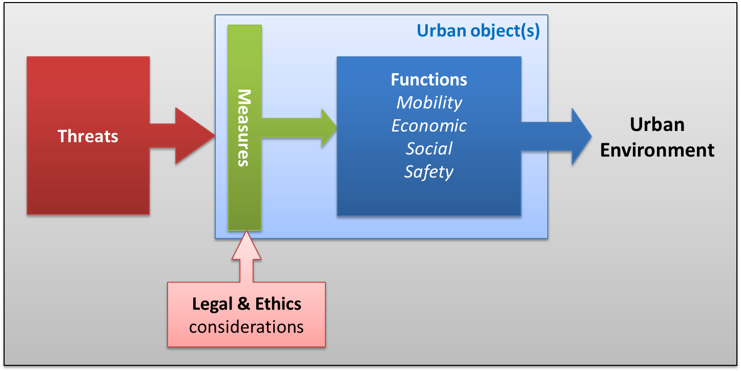
| + | Securipedia offers information about a range of topics related to urban safety and security. Its structure is represented graphically below, and more can be learned [[Structure of the knowledge base|here]]. |
||
| + | <center> |
||
| + | <imagemap> |
||
| + | Image:Schema_contents_wiki.png|800px |
||
| + | |||
| + | rect 50 109 293 419 [[Threat]] |
||
| + | rect 443 47 510 450 [[Measures]] |
||
| + | rect 327 552 473 677 [[Legal aspects]] |
||
| + | rect 475 552 633 681 [[Ethics|Ethics aspects]] |
||
| + | rect 768 180 913 220 [[Mobility]] |
||
| + | rect 757 226 918 268 [[Economic]] |
||
| + | rect 788 272 893 310 [[Social aspects|Social]] |
||
| + | rect 783 314 890 360 [[Safety]] |
||
| + | rect 656 109 1017 420 [[Function|Functions]] |
||
| + | rect 419 29 1069 466 [[Urban object]] |
||
| + | |||
| + | desc bottom-left |
||
| + | </imagemap> |
||
| + | </center> |
||
| + | |||
| + | A tool to asses the potential risk arising from planned or considered changes to the urban environment ('Securban' tool) is available free for use [https://drive.google.com/file/d/0B7rxBbyySsUbcS1mZUxILWJpYXM/view?usp=sharing here]. Instructions to its use are provided [[How to Use the Concept Tool|here]]. |
||
| + | |||
| + | Urban Securipedia came into existence under the EU FP7 project VITRUV and was designed to provide extensive security-related information and tooling for those involved in the design of urban areas (i.e. urban planners). Later, as a result of the EU ISF project [[PRoTECT research project|PRoTECT]], Urban Securipedia was updated to include information and tooling for protecting events held in public space against terrorist attacks. |
||
| + | |||
| + | <HR> |
||
| + | <small><center> |
||
| − | Urban Securipedia is one of two inter‐related components of computer assisted support for urban planners, to support decision-making with regard to the security of cities concerning concrete problems or goals. Each component, namely the Knowledge Base (i.e. this Urban Securipedia) and the Risk Assessment (SecuRbAn) work closely together in supporting the urban planner in a way that is described in the [[How to Use the Concept Tool|how to use]] guide. |
||
| + | <p><br>Contributions or comments? Use the entry in the left sidebar to contact the editors! <br></p> |
||
| + | </center></small> |
||
| + | [[File:PRoTECT-logo.png|link=PRoTECT_research_project|alt=|right|200x100px]][[File:VITRUV_logo.png|alt=|left|100x100px]][[File:EU logo.jpg|link=|alt=|center|100x100px]] |
||
| − | <small>Urban Securipedia is developed as part of the [http://www.project-vitruv.eu Vitruv project], co-funded by the European Commission within the Seventh Research Framework Programme (2007-2013).</small> |
||
Latest revision as of 11:47, 1 June 2023
Urban Securipedia is an urban safety and security knowledge base for local government and other organisations responsible for or involved in the safety and security of people and objects in the urban area. Examples of Securipedia users are: urban planners, municipality staff and law enforcement agencies responsible for the security of public space, and public event planners.
Urban Securipedia provides a structured approach to managing risk, providing practical tools for security concept development, security risk assessment and security technology evaluation, among others.
The knowledge within Urban Securipedia can be accessed either by selecting the aspect of interest, the urban area of interest or simply by searching for a keyword:
| Enter by aspect (select from below) |
Enter by urban object type (hover over different land uses below) |
Enter by specific keyword (as per top right of screen) |
|---|---|---|
 |
 |
Search by specific keyword: |
Securipedia offers information about a range of topics related to urban safety and security. Its structure is represented graphically below, and more can be learned here.

A tool to asses the potential risk arising from planned or considered changes to the urban environment ('Securban' tool) is available free for use here. Instructions to its use are provided here.
Urban Securipedia came into existence under the EU FP7 project VITRUV and was designed to provide extensive security-related information and tooling for those involved in the design of urban areas (i.e. urban planners). Later, as a result of the EU ISF project PRoTECT, Urban Securipedia was updated to include information and tooling for protecting events held in public space against terrorist attacks.
Contributions or comments? Use the entry in the left sidebar to contact the editors!