Difference between revisions of "Urban object"
Jump to navigation
Jump to search

| (19 intermediate revisions by the same user not shown) | |||
| Line 1: | Line 1: | ||
[[Category:Urban object]] |
[[Category:Urban object]] |
||
={{PAGENAME}}= |
|||
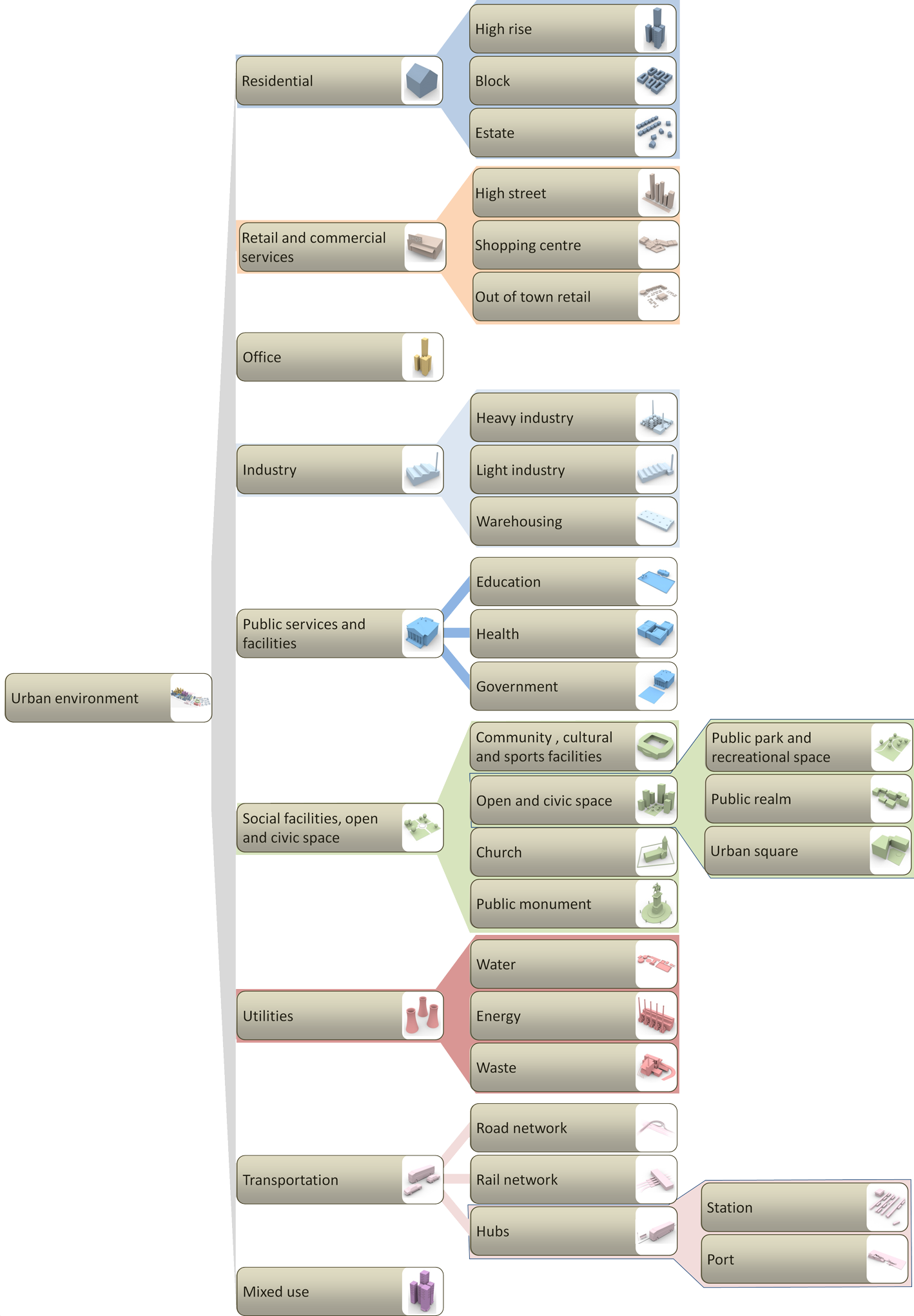
An Urban object is a physical structure within the urban built environment. |
An Urban object is a physical structure within the urban built environment. |
||
| Line 7: | Line 6: | ||
<imagemap> |
<imagemap> |
||
| ⚫ | |||
| ⚫ | |||
| ⚫ | |||
| ⚫ | |||
| ⚫ | |||
| ⚫ | |||
| ⚫ | |||
| ⚫ | |||
| ⚫ | |||
| ⚫ | |||
| ⚫ | |||
| ⚫ | |||
| ⚫ | |||
| ⚫ | |||
| ⚫ | |||
| ⚫ | |||
| ⚫ | |||
| ⚫ | |||
| ⚫ | |||
| ⚫ | |||
| ⚫ | |||
| ⚫ | |||
poly 414 932 794 928 798 1018 420 1024 [[Public services and facilities|Public services and facilities]] |
|||
| ⚫ | |||
| ⚫ | |||
| ⚫ | |||
| ⚫ | |||
| ⚫ | |||
| ⚫ | |||
rect 416 1778 816 1862 [Transportation|Transportation infrastructure]] |
|||
| ⚫ | |||
| ⚫ | |||
poly 1652 1824 1258 1826 1232 1866 826 1864 828 1960 1220 1948 1276 1990 1642 1982 [[Hub|Hub: transfer node in a transport network]] |
|||
| ⚫ | |||
#<!-- Created by Online Image Map Editor (http://www.maschek.hu/imagemap/index) --> |
|||
</imagemap> |
</imagemap> |
||
<imagemap> |
|||
Image:Structure_urban_objects.png|800px| |
|||
poly 89 77 277 79 278 8 490 6 489 213 278 213 275 152 90 151 90 104 [[Residential|Residential: housing facilities for living purposes]] |
|||
poly 93 280 279 274 281 211 492 216 491 416 278 416 276 346 92 346 [[Retail and commercial services|Retail: structures designed designated for the purpose of housing economic activities that fulfil the role of goods and service provision.]] |
|||
rect 89 344 274 411 [[Office|Office space]] |
|||
poly 86 444 278 442 279 407 488 411 493 546 278 541 277 511 86 511 [[Industry|Industry]] |
|||
| ⚫ | |||
rect 280 548 494 607 [[Educational facilities|Educational facilities]] |
|||
rect 279 612 495 675 [[Health facilities|Health facilities]] |
|||
rect 279 680 495 740 [[Government asset|Government assets]] |
|||
poly 89 811 282 805 279 740 496 745 492 805 286 806 286 877 495 874 496 942 272 940 276 876 91 876 [[Social facilities, open and civic space|Social facilities, open and civic space]] |
|||
poly 690 742 501 743 499 810 290 808 292 870 496 871 500 945 685 943 [[Open and civic space|Open and civic space: public space designed for recreation]] |
|||
poly 88 1010 278 1006 277 940 488 941 496 1143 280 1139 273 1074 88 1080 [[Utilities|Utilities: all infrastructures with supportive functions related to the health and well-being of the citizens, excluding transportation]] |
|||
| ⚫ | |||
rect 284 1145 494 1210 [[Road network|Road network: road infrastructure connecting hubs]] |
|||
rect 285 1215 494 1278 [[Rail network|Rail network: rail infrastructure connecting hubs]] |
|||
| ⚫ | |||
rect 89 1278 277 1341 [[Mixed use|Mixed use: a facility or location, designated for more than one function]] |
|||
#<!-- Created by Online Image Map Editor (http://www.maschek.hu/imagemap/index) --> |
|||
</imagemap> |
|||
{{references}} |
|||
= MAP = |
|||
<websiteFrame> |
|||
website=http://securipedia.eu/cool/index.php?wiki=securipedia.eu&concept=Urban_planning |
|||
height=1023 |
|||
width=100% |
|||
border=0 |
|||
scroll=auto |
|||
align=middle |
|||
</websiteFrame> |
|||
<headertabs/> |
|||
Latest revision as of 10:47, 3 January 2014
An Urban object is a physical structure within the urban built environment.
Types of urban objects
Within the Securipedia, the following categorisation of urban objects is used (click map for link):
