Difference between revisions of "Plan level tools"
| (33 intermediate revisions by 2 users not shown) | |||
| Line 1: | Line 1: | ||
| ⚫ | |||
= {{PAGENAME}} = |
|||
| ⚫ | |||
== Three planning stages == |
== Three planning stages == |
||
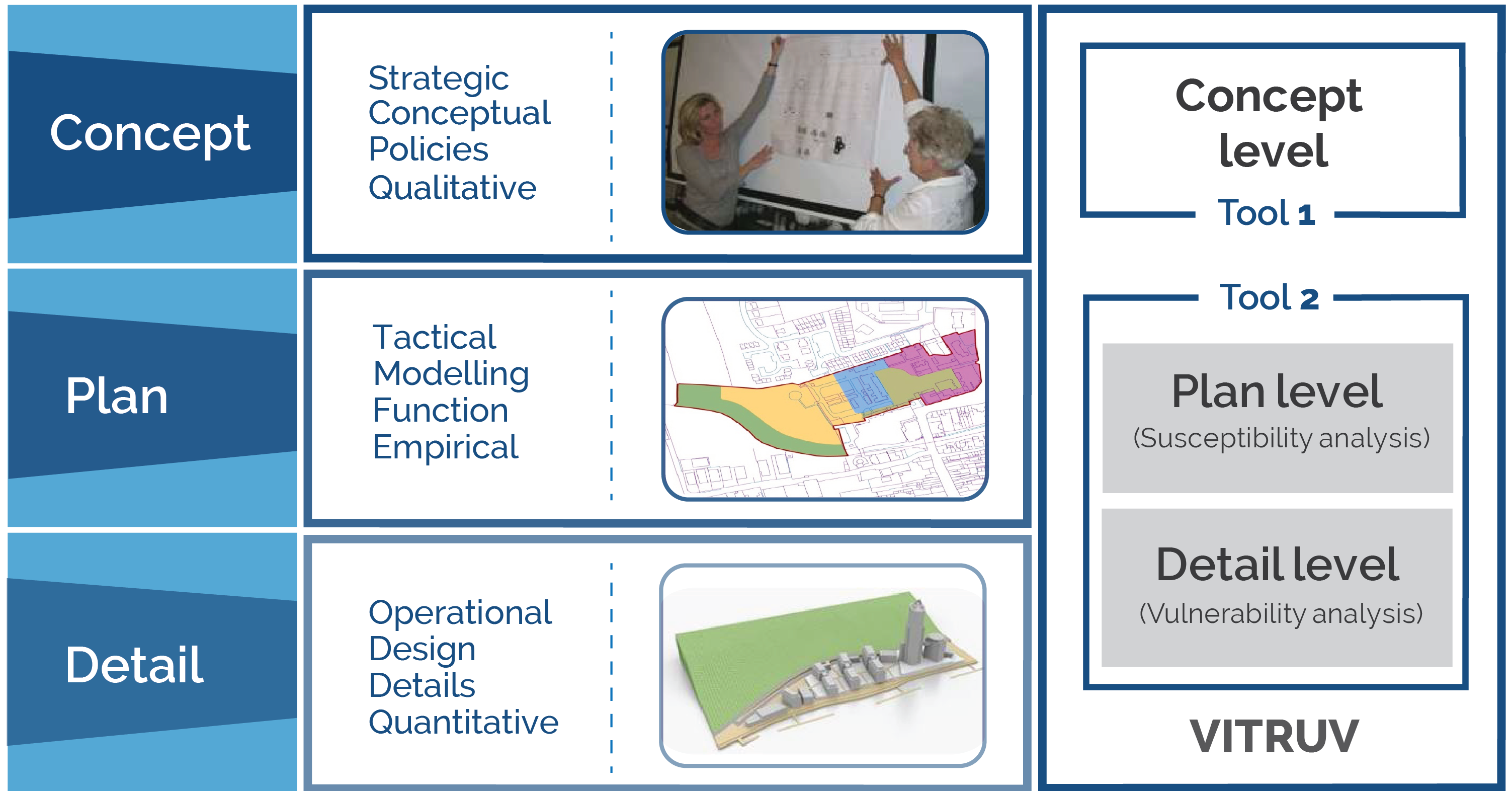
[[Image:planning stages.png|thumb|right|300px|The three planning stages in urban development]]Departing from a concrete goal or problem, the first step in finding a fitting solution in the urban space is to investigate possible solution directions, utilising the [[Concept level tools]]. |
[[Image:planning stages.png|thumb|right|300px|The three planning stages in urban development]]Departing from a concrete goal or problem, the first step in finding a fitting solution in the urban space is to investigate possible solution directions, utilising the [[Concept level tools]]. |
||
The plan level involves the urban planner formulating, with an additional layer of examination, possible solutions to the problem or challenge at hand. These possible solutions are analysed in the context of relevant characteristics and a screening or feasibility assessment for each may be conducted. Arising from the results of this assessment, possible solutions are discounted, compared and ‘weighed up’, and the most appropriate option available (or combination thereof) is selected (which should, ultimately, accord with the proper planning and sustainable development of the city). The Plan level tools developed within the project |
The plan level involves the urban planner formulating, with an additional layer of examination, possible solutions to the problem or challenge at hand. These possible solutions are analysed in the context of relevant characteristics and a screening or feasibility assessment for each may be conducted. Arising from the results of this assessment, possible solutions are discounted, compared and ‘weighed up’, and the most appropriate option available (or combination thereof) is selected (which should, ultimately, accord with the proper planning and sustainable development of the city). The Plan level tools developed within the project VITRUV will support the urban planner in ensuring a holistic approach to his/her duties, by informing from him/her of the security (and connected safety) aspects. |
||
After selecting one (or more) solutions, this is worked out and refined in the detail level, where the [[Detail level tools|Detail level tool]] from the project |
After selecting one (or more) solutions, this is worked out and refined in the detail level, where the [[Detail level tools|Detail level tool]] from the project VITRUV will assist. |
||
== Goal of the |
== Goal of the plan level tool == |
||
The goal of the plan level tool is to provide a susceptibility analysis for urban objects (visualised as simple blocks at this stage) during the planning stage. It facilitates measures for probability of events and the extent of loss associated with an event being realised. It is an easy-to-use, fast-running computer tool consisting of a Window application for Windows and MAC operating systems. The goal of the plan level tool is to focus on crime and terrorism, with natural disasters a potential 'add-on' in future versions. |
|||
Goal of the concept-level tool is to provide easy-to-use, computer assisted support for city planners in order to systematically include security considerations in the concept stage of their planning. |
|||
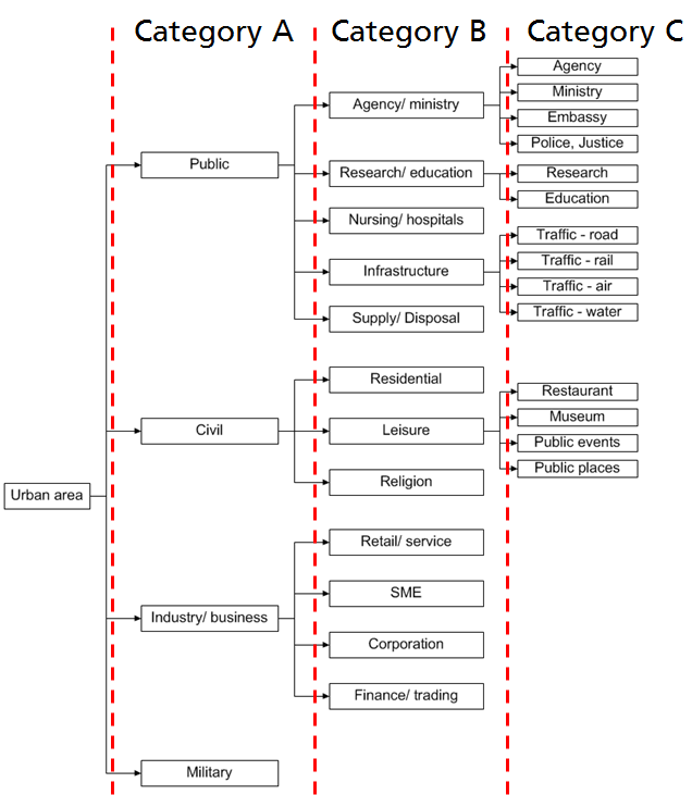
To provide measures for the probability of events and the extent of losses empirical data for terrorist attacks and crime are provided. This was realized using the Terrorist Event Database (TED)<ref>U. Siebold, J. Ziehm, I. Häring, ''Terror Event Database and Analysis Software'', in Future Security, 4th Security Research Conference, Karlsruhe, Germany, 2009</ref> and police recorded crime from the police force area of [http://www.westyorkshire.police.uk/ West Yorkshire Police]. This empirical data allows a risk assessment in dependency of the usage of the urban object. For differentiation of the target a classification of the urban area in dependency of the usage was carried out, as depicted in the figure below. |
|||
The Concept Tool is composed of two inter-related components: the Knowledge Base (Securipedia) and the Risk Assessment (Securban). These components work closely together in supporting the urban planner in a way that is described in the [[How to Use the Concept Tool|how-to-use guide]]. |
|||
[[Image:Structure target classification.png|600px|Use-based classification of urban targets for terrorists]] |
|||
=== Risk Assessment tool (SecuRbAn)=== |
|||
The Risk Assessment tool, a supporting tool for doing a quick security scan to indicate where possible security issues may be, will facilitate the urban planner in making a quick assessment of the security issues that are most relevant to a project or scheme. An important aspect of the Risk Assessment tool is the timely manner in which the urban planner can eliminate the security issues that are not of interest in a specific project or scheme, in order to focus attention on relevant issues. The Risk Assessment is not intended to be very detailed or exhaustive in its assessment, and is intended to indicate possible security issues; the actual assessment is made by the user. The Risk Assessment will link with relevant pages, as appropriate, in the Knowledge Base to provide sufficient information about the security risks, their possible solutions and the impact upon other dimensions to allow urban planners to make well-considered decisions regarding security issues in their development process. |
|||
Within Securipedia [[Urban object|another structure]] for the urban environment is used. The structures are different because on plan Level you need a classification of the targets in dependency of its usage. Here it is also important, that specific building types are listed up explicit. Embassies, for example, have the highest empirical frequency for a terror attack. Another reason for the difference is that for the database query it was necessary to use categories, which can be retrieved from TED. |
|||
Risk Assessment Primary Output:<br /> |
|||
* Prioritised list of security issues deemed relevant for addressing the project;<br /> |
|||
* Links to relevant Knowledge Base pages;<br /> |
|||
* A complete list of all possible security issues indicating its relevance to the project (allows quick comparison to see the changes between two risk assessments).<br /> |
|||
== Calculation method == |
|||
The SecuRbAn tool is freely downloadable at http://www.vitruv-project.eu/. |
|||
Within the approach the classic definition of risk computation is used. Therefore the empirical risk R for a single building is defined as a product of the susceptibility of a target S and the consequence C. |
|||
=== Knowledge Base (Securipedia) === |
|||
The Knowledge Base provides the background understanding on subjects that are directly or indirectly related to security for the urban planner. The Knowledge Base has been formulated having regard to the composition of the Urban Environment, which includes Urban Objects (with functions such as Mobility, Economy, Social and Safety etc.), Legal and Ethical Aspects, and urban threats (means and motives). The Knowledge Base explains the relationships between the concepts, relevant to security assessment, for urban planners. For more information about the topics contained in the knowledge base, see [[structure of the knowledge base]]. |
|||
<math>R=S \cdot C</math> |
|||
The Knowledge Base has been purposely designed to be user-friendly and intuitive; it does not provide specific advice about a project but simply provides advice about what subjects to address in the process, and how one can address these subjects. |
|||
The susceptibility can be subdivided in the frequency F and the product of all scaling factors w. The latter are used to consider urban security or other factors, like a high crime rate or increased video or police surveillance which could increase or decrease the probability of an event. Therefore the scaling factors are used to produce more realistic results. In formulas: |
|||
Securipedia Knowledge Base Primary Output:<br /> |
|||
* The source of information on security issues highlighted by the Risk Assessment (with links to relevant pages in the Knowledge Base);<br /> |
|||
* A wider repository of information on subjects that are relevant to both the urban planning process and security;<br /> |
|||
* Links to outside sources where relevant information can be found that is beyond the level of detail that the Knowledge Base aims for.<br /> |
|||
<math>S=F \cdot w</math> |
|||
=== Applied Example of Concept Tool === |
|||
The city authority planning department has recognised that the public transport network has not developed in line with urban population growth and the rate of economic development. The planning department is investigating the suitability of a new tram line through the city connecting with existing bus and rail services at strategic locations to address a near chronic traffic congestion problem, and whether such a proposal would fit with the objectives of the City Integrated Land Use and Transportation Development Plan. |
|||
where |
|||
A range of additional factors need to be considered from the outset, including: |
|||
* mechanisms to stimulate demand to generate a modal shift in favour of public transport;<br /> |
|||
* consideration of future population growth zones (in particular residential and employment areas, which typically generate the highest transport demand);<br /> |
|||
* the regulatory framework (such as congestion pricing, removal of trucks from city areas etc.); and,<br /> |
|||
* the security and safety aspects of the system, and its components (tram station design, locations, etc.). |
|||
<math>w=\prod_n^{i=0} w_i</math> |
|||
The SecuRbAn tools can provide the city authority planning department with the information what security issues might arise from the intended changes in the built environment. The Securipedia provides the necessary information what mechanisms cause these issues and what might be done about it. This information can be integrated in the iterative planning process, ensuring a design with a appropriate balance between the various goals to be pursued. |
|||
== Results == |
|||
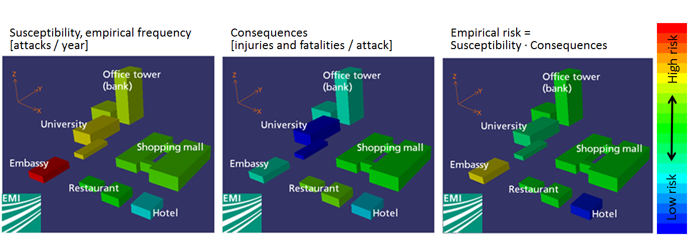
With the empirical data in dependency of the target (e.g. an open space or an embassy) the user of the plan level tool is able to calculate the frequency of an event and the consequences. For terror events the consequences are shown with extent of losses per attack (injuries and fatalities) and for crime with monetary damage. Finally the empirical risk could be determined using these two empirical parameters. |
|||
As a result on plan level end-user of the tool are able to detect hotspots at risk, mostly endangered districts and have a basis for security measures. |
|||
[[Image:Using the plan tool.png|800px|Visualization of susceptibility, consequences and the empirical risk using the VITRUV plan level tool.]] |
|||
{{references}} |
{{references}} |
||
= MAP = |
|||
<websiteFrame> |
|||
website=http://securipedia.eu/cool/index.php?concept=<replace with pagename> |
|||
width=100% |
|||
border=0 |
|||
scroll=auto |
|||
align=middle |
|||
</websiteFrame> |
|||
<headertabs/> |
|||
Latest revision as of 11:05, 1 February 2017
The Plan level tool is the tool provided in the project VITRUV to support the second of three stages distinguished in the process of urban planning.
Contents
Three planning stages
Departing from a concrete goal or problem, the first step in finding a fitting solution in the urban space is to investigate possible solution directions, utilising the Concept level tools.
The plan level involves the urban planner formulating, with an additional layer of examination, possible solutions to the problem or challenge at hand. These possible solutions are analysed in the context of relevant characteristics and a screening or feasibility assessment for each may be conducted. Arising from the results of this assessment, possible solutions are discounted, compared and ‘weighed up’, and the most appropriate option available (or combination thereof) is selected (which should, ultimately, accord with the proper planning and sustainable development of the city). The Plan level tools developed within the project VITRUV will support the urban planner in ensuring a holistic approach to his/her duties, by informing from him/her of the security (and connected safety) aspects.
After selecting one (or more) solutions, this is worked out and refined in the detail level, where the Detail level tool from the project VITRUV will assist.
Goal of the plan level tool
The goal of the plan level tool is to provide a susceptibility analysis for urban objects (visualised as simple blocks at this stage) during the planning stage. It facilitates measures for probability of events and the extent of loss associated with an event being realised. It is an easy-to-use, fast-running computer tool consisting of a Window application for Windows and MAC operating systems. The goal of the plan level tool is to focus on crime and terrorism, with natural disasters a potential 'add-on' in future versions.
To provide measures for the probability of events and the extent of losses empirical data for terrorist attacks and crime are provided. This was realized using the Terrorist Event Database (TED)[1] and police recorded crime from the police force area of West Yorkshire Police. This empirical data allows a risk assessment in dependency of the usage of the urban object. For differentiation of the target a classification of the urban area in dependency of the usage was carried out, as depicted in the figure below.
Within Securipedia another structure for the urban environment is used. The structures are different because on plan Level you need a classification of the targets in dependency of its usage. Here it is also important, that specific building types are listed up explicit. Embassies, for example, have the highest empirical frequency for a terror attack. Another reason for the difference is that for the database query it was necessary to use categories, which can be retrieved from TED.
Calculation method
Within the approach the classic definition of risk computation is used. Therefore the empirical risk R for a single building is defined as a product of the susceptibility of a target S and the consequence C.
The susceptibility can be subdivided in the frequency F and the product of all scaling factors w. The latter are used to consider urban security or other factors, like a high crime rate or increased video or police surveillance which could increase or decrease the probability of an event. Therefore the scaling factors are used to produce more realistic results. In formulas:
where
Results
With the empirical data in dependency of the target (e.g. an open space or an embassy) the user of the plan level tool is able to calculate the frequency of an event and the consequences. For terror events the consequences are shown with extent of losses per attack (injuries and fatalities) and for crime with monetary damage. Finally the empirical risk could be determined using these two empirical parameters. As a result on plan level end-user of the tool are able to detect hotspots at risk, mostly endangered districts and have a basis for security measures.
Footnotes and references
- ↑ U. Siebold, J. Ziehm, I. Häring, Terror Event Database and Analysis Software, in Future Security, 4th Security Research Conference, Karlsruhe, Germany, 2009


