Difference between revisions of "Plan level tools"
| Line 15: | Line 15: | ||
[[Image:Structure target classification.png|x600px|Use-based classification of urban targets for terrorists.png]] |
[[Image:Structure target classification.png|x600px|Use-based classification of urban targets for terrorists.png]] |
||
== Calculation method == |
|||
Within the approach the classic definition of risk computation is used. Therefore the empirical risk R for a single building is defined as a product of the susceptibility of a target S and the consequence C, see equation (1). |
|||
<math>S=F · w</math> |
|||
The susceptibility can be subdivided in the frequency F and the product of all scaling factors w. The latter are used to consider urban security or other factors, like a high crime rate or increased video or police surveillance which could increase or decrease the probability of an event. Therefore the scaling factors are used to produce more realistic results. |
|||
S=F ∙w |
|||
w=∏_(i=0)^n▒w_i (2) |
|||
== Results == |
|||
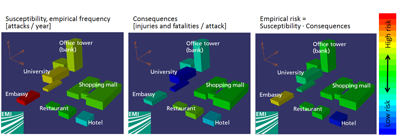
With the empirical data in dependency of the target (e.g. an open space or an embassy) the user of the plan level tool is able to calculate the frequency of an event and the consequences. For terror events the consequences are shown with extent of losses per attack (injuries and fatalities) and for crime with monetary damage. Finally the empirical risk could be determined using these two empirical parameters. |
With the empirical data in dependency of the target (e.g. an open space or an embassy) the user of the plan level tool is able to calculate the frequency of an event and the consequences. For terror events the consequences are shown with extent of losses per attack (injuries and fatalities) and for crime with monetary damage. Finally the empirical risk could be determined using these two empirical parameters. |
||
As a result on plan level end-user of the tool are able to detect hotspots at risk, mostly endangered districts and have a basis for security measures. |
As a result on plan level end-user of the tool are able to detect hotspots at risk, mostly endangered districts and have a basis for security measures. |
||
Revision as of 14:18, 23 April 2013
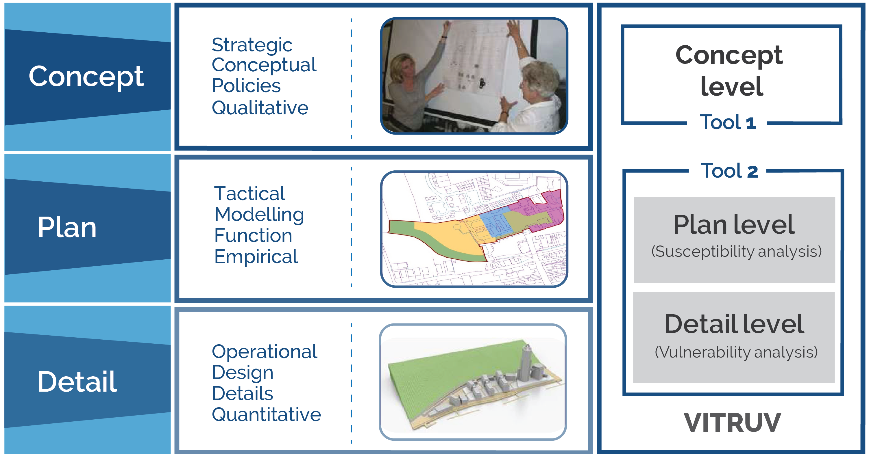
The Plan level tool is the tool provided in the project VITRUV to support the second of three stages distinguished in the process of urban planning.
Contents
Three planning stages
Departing from a concrete goal or problem, the first step in finding a fitting solution in the urban space is to investigate possible solution directions, utilising the Concept level tools.
The plan level involves the urban planner formulating, with an additional layer of examination, possible solutions to the problem or challenge at hand. These possible solutions are analysed in the context of relevant characteristics and a screening or feasibility assessment for each may be conducted. Arising from the results of this assessment, possible solutions are discounted, compared and ‘weighed up’, and the most appropriate option available (or combination thereof) is selected (which should, ultimately, accord with the proper planning and sustainable development of the city). The Plan level tools developed within the project VITRUV will support the urban planner in ensuring a holistic approach to his/her duties, by informing from him/her of the security (and connected safety) aspects.
After selecting one (or more) solutions, this is worked out and refined in the detail level, where the Detail level tool from the project VITRUV will assist.
Goal of the plan level tool
The goal of the plan level tool is to provide a susceptibility analysis for urban objects (visualised as simple blocks at this stage) during the planning stage. It facilitates measures for probability of events and the extent of loss associated with an event being realised. It is an easy-to-use, fast-running computer tool consisting of a Window application for Windows and MAC operating systems. The goal of the plan level tool is to focus on crime and terrorism, with natural disasters a potential 'add-on' in future versions.
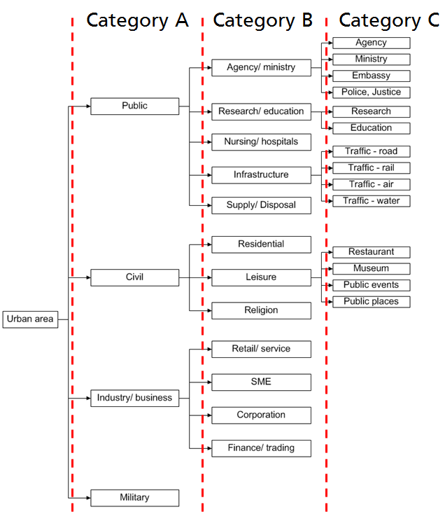
To provide measures for the probability of events and the extent of losses empirical data for terrorist attacks and crime are provided. This was realized using the Terrorist Event Database (TED)[1] and police recorded crime from the police force area of West Yorkshire Police. This empirical data allows a risk assessment in dependency of the usage of the urban object. For differentiation of the target a classification of the urban area in dependency of the usage was carried out, as depicted in the figure below.
Calculation method
Within the approach the classic definition of risk computation is used. Therefore the empirical risk R for a single building is defined as a product of the susceptibility of a target S and the consequence C, see equation (1).
Failed to parse (Conversion error. Server ("cli") reported: "SyntaxError: Expected "-", "[", "\\", "\\begin", "\\begin{", "]", "^", "_", "{", "}", [ \t\n\r], [%$], [().], [,:;?!'], [/|], [0-9], [><~], [\-+*=], or [a-zA-Z] but "&" found.in 1:20"): {\displaystyle S=F · w}
The susceptibility can be subdivided in the frequency F and the product of all scaling factors w. The latter are used to consider urban security or other factors, like a high crime rate or increased video or police surveillance which could increase or decrease the probability of an event. Therefore the scaling factors are used to produce more realistic results.
S=F ∙w
w=∏_(i=0)^n▒w_i (2)
Results
With the empirical data in dependency of the target (e.g. an open space or an embassy) the user of the plan level tool is able to calculate the frequency of an event and the consequences. For terror events the consequences are shown with extent of losses per attack (injuries and fatalities) and for crime with monetary damage. Finally the empirical risk could be determined using these two empirical parameters. As a result on plan level end-user of the tool are able to detect hotspots at risk, mostly endangered districts and have a basis for security measures.
Footnotes and references
- ↑ U. Siebold, J. Ziehm, I. Häring, Terror Event Database and Analysis Software, in Future Security, 4th Security Research Conference, Karlsruhe, Germany, 2009


